Mansa Musa
Mali, pilgrimage and connections across the Sahara
Public life
On this page
Life overview
Musa ruled the Mali Empire in the early fourteenth century. His pilgrimage made its wealth and connections more widely known, but agriculture, trade, labour and local institutions sustained that power.
Places and turning points
Dashed lines show the order of selected places, not an exact travel route.
c. 1312 · conventional accession
Ruling from the Mali heartland
Upper Niger / Mali heartland Representative area
Musa’s accession is commonly placed around 1312, though reconstructions differ. The state drew on farming communities, gold-producing regions and trade linking the savanna with the Sahara. This regional marker represents the political heartland: the medieval capital’s location is debated, and neither his birthplace nor his court can be fixed here with certainty.
Regional reference point, not a verified camp or exact route.
Representative coordinates · 12.5°, -8.3°
1324
A king’s visit becomes international news
Cairo City-level representative point
On the journey to Mecca, Musa visited Mamluk Egypt and was received in Cairo. Reports of his caravan and gifts circulated widely, making Mali’s resources visible to distant observers. Their impressive numbers are literary and historical reports, not audited accounts; the visit also involved diplomacy and the work of a large travelling household.
City-level marker; no individual building is asserted.
Representative coordinates · 30.045°, 31.236°
1324–1325 · journey period
Pilgrimage within a wider Muslim world
Mecca City-level representative point
Musa’s pilgrimage linked a West African court with religious and scholarly networks reaching across North Africa and the Hijaz. Mecca was the sacred destination, but surviving summaries do not reconstruct every stop or daily movement. The dates describe the overall journey, not a claim that he remained in the city for two continuous years.
City-level marker; no individual building is asserted.
Representative coordinates · 21.3891°, 39.8579°
After c. 1325 · broad phase
Patronage after the pilgrimage
Timbuktu City-level representative point
UNESCO associates the early Djingareyber Mosque with Musa’s return from pilgrimage. This connects royal patronage with an existing West African urban tradition. The building was later rebuilt and enlarged, and Timbuktu’s best-known scholarly flourishing came in subsequent centuries. Neither the present fabric nor all later learning can be attributed to one ruler.
City-level marker; no individual building is asserted.
Representative coordinates · 16.7666°, -3.0026°
c. 1330s · late reign
A reign with uncertain endpoints
Upper Niger / Mali heartland Representative area
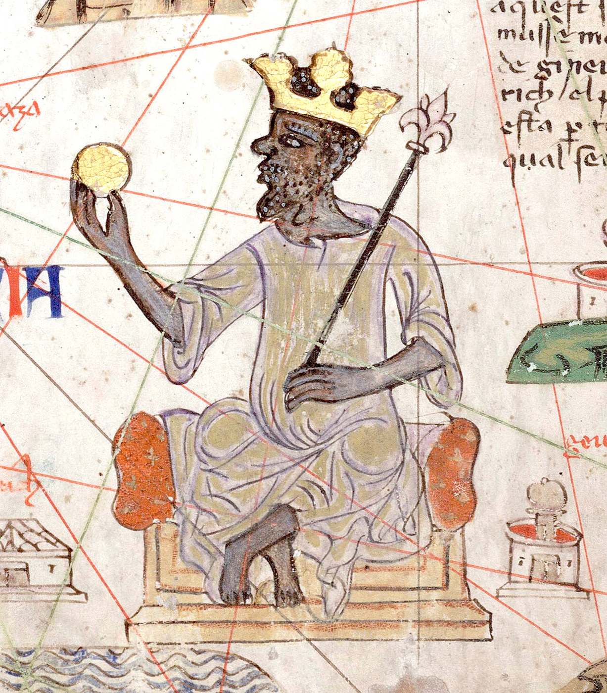
Musa’s later reign is less firmly dated than his pilgrimage. A conventional reconstruction ends his rule around 1337, but other chronologies exist. The regional marker returns to Mali’s political heartland without inventing a deathplace. Later European maps celebrated his gold; they document the circulation of a reputation rather than a contemporary portrait from life.
Regional reference point, not a verified camp or exact route.
Representative coordinates · 12.5°, -8.3°
Legacy and context
His patronage became associated with Timbuktu and wider Islamic networks. Medieval reports of gold and later maps shaped his reputation; a modern ranking of personal wealth cannot be reliably calculated.
Bibliography
- British Library: African kings on medieval maps
- OpenStax, Rice University: Medieval Sub-Saharan Africa
- UNESCO: Timbuktu
References support specific dates and context. Bibliographies are displayed as text.
Image and source
Mansa Musa in the Catalan Atlas
Detail from the Catalan Atlas, c. 1375–1380, attributed to Abraham Cresques. Its image of Mansa Musa is a later European representation, not an eyewitness record of his 1324 pilgrimage.
- Creator
- attributed to Abraham Cresques
- Collection / image provider
- Bibliothèque nationale de France · Wikimedia Commons
- Source and reuse
- Source record · Public domain
The source identifies this image as public domain. Consult its item-specific rights record and terms below; CivAtlas does not claim new copyright or grant additional rights in this image.
Public domain, as identified in the source record. Source credit: attributed to Abraham Cresques. Reuse terms: Public domain.